


Introduction to Sarangkot View Point
Sarangkot is the single most photographed sunrise in Nepal outside the high mountains themselves, and also, if you get the timing or the weather wrong, one of the most disappointing 4:30 a.m. wake-up calls a traveler can have. The difference between a life-changing view of the Annapurna range turning gold at dawn and a grey, cloud-choked hilltop crowded with tired tourists usually comes down to a handful of details most quick guides skip — which month you’re visiting, whether you drive or hike, and what time you actually need to leave Lakeside.
This guide covers everything genuinely useful about Sarangkot: exact altitude and distance figures, every way to get there (drive, hike, or Nepal’s first cable car), the real difference between sunrise and sunset here, what mountains you’re actually looking at, and the practical logistics that separate a good visit from a wasted early morning. We’ve built this from years of running sunrise trips up to Sarangkot with Trek Trove Nepal.
Quick Answer
- Altitude: approximately 1,590–1,600 meters (5,220–5,250 feet); some sources cite figures up to 1,695 meters depending on the exact vantage point measured
- Distance from Lakeside Pokhara: roughly 5 km direct/straight-line, 10–12 km by the winding road, or 8–9 km by the hiking trail
- Time by road: 30–45 minutes by car or taxi
- Time by cable car: roughly 10 minutes, covering about 2.2–2.4 km
- Time by foot: 2–4 hours, depending on route and fitness
- Best for: sunrise views of Annapurna South, Machhapuchhre (Fishtail Mountain), Dhaulagiri, Manaslu, and Annapurna I, plus paragliding launches
- Best season: October–November and March–April for the clearest mountain visibility
- Entrance fee: approximately NPR 100 per person
Where Sarangkot Actually Is and How High It Sits
Sarangkot is a hilltop village on the northwestern edge of the Pokhara Valley, in Nepal’s Gandaki Province, roughly 5 kilometers as the crow flies from the Lakeside tourist area along Phewa Lake — though the actual road winds considerably more than that straight-line distance suggests.
The altitude figure varies slightly by source, similar to the pattern you’ll notice with many Nepali landmarks: most reliable, commonly cited sources place it at 1,592 to 1,600 meters, a small number of tour operator listings round it to 1,695 meters, likely referencing a slightly different specific point on the hill (the fort ruins near the summit sit a little higher than the main viewing platform). For practical purposes, treat Sarangkot as sitting at roughly 1,600 meters — high enough to comfortably clear the Pokhara Valley’s morning fog and haze, but nowhere near high enough to cause altitude sickness for the vast majority of visitors.
For comparison, Phewa Lake below sits at approximately 742 meters, meaning Sarangkot’s viewing point rises roughly 850 meters above the lake itself — enough elevation gain to transform the view from a lakeside town into a genuine Himalayan panorama, without requiring any of the acclimatization planning that higher-altitude destinations in Nepal demand.
What You Actually See From Sarangkot
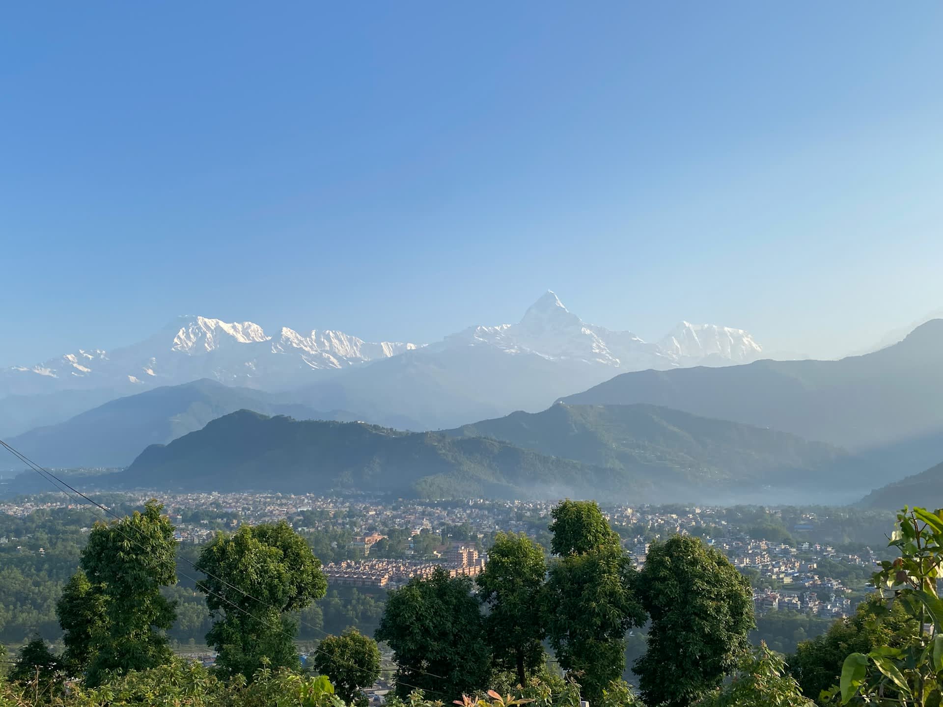
The reason Sarangkot draws crowds every single morning of the year, weather permitting, is the sheer scale and proximity of the mountain panorama on a clear day.
| Peak | Approximate Height | Position Relative to Sarangkot |
|---|---|---|
| Machhapuchhre (Fishtail Mountain) | 6,993 m | Directly north, the most iconic and recognizable peak from Sarangkot due to its distinctive twin-pointed summit |
| Annapurna South | 7,219 m | Northwest |
| Annapurna I | 8,091 m | Northwest, one of the world’s 8,000-meter peaks |
| Dhaulagiri | 8,167 m | West, visible on clear days |
| Manaslu | 8,163 m | East, visible on especially clear days |
| Lamjung Himal | 6,983 m | East |
Machhapuchhre, often translated as “Fish Tail” for its distinctive forked summit when viewed from certain angles, is the visual centerpiece of the Sarangkot panorama and the peak most travelers photograph first — it’s also a sacred mountain that has never been officially summited, which adds a layer of mystique many visitors find compelling once they learn about it on-site or from a guide.
Below the mountain panorama, Phewa Lake and the sprawl of Pokhara city itself form the foreground, with the lake’s water frequently catching the first colors of sunrise before the sky above the peaks does — a detail worth watching for if you’re photographing the scene rather than just viewing it.
How to Reach Sarangkot: Every Method Compared
| Method | Distance | Time | Cost (approx.) | Notes |
|---|---|---|---|---|
| Private taxi/car | ~10–12 km by road | 30–45 minutes | NPR 1,500–2,500 round trip, shared among passengers | Most common method, especially for sunrise |
| Shared/local jeep or minibus | ~10–12 km by road | 30–45 minutes | Lower cost per person than private taxi | Less flexible on timing |
| Annapurna Cable Car | 2.2–2.4 km (gondola line) | ~10 minutes | USD 9 round trip (foreigners); NPR 800 (SAARC); NPR 700 (Nepali citizens) | Departs from Sedibagar/Seti Bagar station near Lakeside |
| Hiking | ~8–9 km trail | 2–4 hours | Free (aside from entrance fee) | Moderate elevation gain of roughly 850 m from lake level |
| Paragliding (one-way down) | N/A | 20–30 minutes in the air | Priced separately as an activity, typically USD 60–100+ | A scenic, unconventional way to descend rather than ascend |
By Road (The Most Common Method)
Most visitors, especially those chasing sunrise, reach Sarangkot by private taxi or shared jeep along the winding hill road from Lakeside. The drive typically takes 30 to 45 minutes, passing through small villages and terraced hillsides as the road climbs. For sunrise specifically, this is the most time-efficient option, since it doesn’t require the 2–3 hours of pre-dawn walking that hiking would demand.
Practical tip: if you’re timing this for sunrise, arrange your taxi the evening before, and confirm a pickup time that accounts for both the 30–45 minute drive and a buffer for finding parking and walking the final stretch up to the main viewing platform — arriving with zero margin for the actual sunrise moment is a common and avoidable disappointment.
By Cable Car (Fastest and Newest Option)
Nepal’s first cable car, the Annapurna Cable Car, opened in March 2022, connecting Sedibagar (near Lakeside) directly to Sarangkot in about 10 minutes, covering a line of roughly 2.2 to 2.4 kilometers. It operates daily from approximately 5:00 a.m. to 6:00 p.m., making it genuinely viable for sunrise visits, provided you check current operating hours before relying on an early departure, since schedules can shift seasonally.
| Ticket Type | Round Trip Price |
|---|---|
| Foreign nationals (all other countries) | USD 9 |
| SAARC nationals | NPR 800 |
| Nepali citizens | NPR 700 |
The cable car is a genuinely pleasant, low-effort way to reach Sarangkot, offering its own aerial views of the Annapurna range and Phewa Lake during the short ride, and it’s a strong option for travelers with limited mobility, since it avoids both the winding drive and the walk up from a parking area that the road option still requires to some degree.
By Hiking
For travelers wanting a more active, immersive approach, a hiking trail connects Lakeside to Sarangkot, covering roughly 8 to 9 kilometers with an elevation gain of up to 850 meters, typically taking 3 to 4 hours for an average hiker. This is rated as an easy-to-moderate trek, well-marked and popular enough that solo hikers regularly complete it without a guide, though starting well before dawn if you’re aiming for sunrise requires a headlamp and some comfort with pre-dawn trail walking.
Honest trade-off: hiking to Sarangkot for sunrise means starting in the dark, roughly 2 to 3 hours before dawn depending on your pace — genuinely rewarding for travelers who want the full experience, but a real commitment compared to the 30-minute taxi ride most visitors choose instead.
Sunrise vs. Sunset at Sarangkot: Which Should You Choose?
This is one of the most common practical questions, and the honest answer is that both have real merit, with different trade-offs.
| Factor | Sunrise | Sunset |
|---|---|---|
| Typical clarity | Often clearer, since morning haze and cloud buildup haven’t yet developed | More prone to afternoon haze and cloud cover, especially outside peak season |
| Crowd levels | Very high — this is Sarangkot’s signature experience | Lower, more relaxed atmosphere |
| Color quality | Peaks turn gold/pink as the sun rises behind them | Similar coloring in reverse, with the added drama of the sun setting over the valley itself |
| Practical timing | Requires a pre-dawn departure, typically 4:30–5:00 a.m. from Lakeside | More convenient timing, fitting naturally into an afternoon itinerary |
| Photography | The classic, most-photographed Sarangkot shot | Less crowded compositions, softer light |
Our honest recommendation: if you can only choose one, sunrise remains the stronger experience for mountain clarity, since Nepal’s hill-station weather pattern typically produces the clearest skies in the early morning before daytime heating builds cloud cover. But if you’re not a morning person, or you’re visiting during a hazier season, a sunset visit is a completely legitimate and less crowded alternative that still delivers strong views on a clear evening.
Best Time of Year to Visit
| Season | Months | Visibility Quality | Notes |
|---|---|---|---|
| Autumn | September–November | Excellent | Widely considered the best season; clear, stable post-monsoon air |
| Winter | December–February | Good, cold mornings | Clear skies common, but pre-dawn temperatures at Sarangkot can be noticeably cold |
| Spring | March–May | Very good | Comparable clarity to autumn; warmer mornings |
| Monsoon | June–August | Poor | Frequent cloud cover; mountain views often obscured entirely |
Autumn (October–November specifically) is the season most consistently associated with the clearest, most reliable Sarangkot mountain views, closely followed by spring (March–April). Monsoon season visits are a genuine gamble — Pokhara sits in a wetter zone than the rain-shadow areas further north, and cloud cover regularly blocks the mountain panorama entirely during these months, even when it’s not actively raining.
What Else There Is to Do at Sarangkot
Sarangkot isn’t purely a sunrise-and-leave destination — there’s enough here to justify spending more time if your schedule allows.
- Paragliding. Sarangkot is one of the world’s most renowned paragliding launch sites, and tandem flights (with a licensed pilot) typically launch from near the hilltop and land down near Phewa Lake, offering a genuinely spectacular aerial view of the Annapurna range and Pokhara Valley during the descent. This is a separately booked and priced activity, distinct from the standard sunrise viewing tour.
- Sarangkot Fort ruins. The hilltop was historically the site of a fort belonging to the small Kingdom of Kaski before Nepal’s unification in the 18th century. The ruins, while modest, add a layer of historical interest for visitors who want more than just a photo stop.
- The viewing tower and platform. A multi-level viewing tower near the summit gives visitors an elevated vantage point above the immediate tree line and surrounding buildings, and is generally considered the best single spot for the classic panoramic photograph.
- Local teahouses and cafés. Several small guesthouses and cafés near the summit serve hot tea and simple breakfast, genuinely useful given how early and cold a sunrise visit can be, especially in winter.
- Short walks around the ridge. Beyond the main viewpoint, the ridge offers additional, less crowded vantage points for travelers willing to walk a short distance away from the main platform.
Entrance Fee and Costs
| Item | Approximate Cost |
|---|---|
| Sarangkot viewpoint entrance fee | NPR 100 per person |
| Private taxi (round trip, shared among group) | NPR 1,500–2,500 |
| Annapurna Cable Car (round trip, foreigner) | USD 9 |
| Guided sunrise tour (including transport) | Roughly USD 15–35 per person, depending on group size and operator |
| Tandem paragliding flight | Roughly USD 60–100+, separately booked |
Sarangkot itself is an inexpensive destination relative to many other Nepal experiences — the entrance fee is nominal, and even a private taxi split among a small group keeps per-person cost low. Paragliding is the one activity here that meaningfully changes your total budget for the visit.
Sarangkot vs. Other Pokhara Viewpoints
Sarangkot isn’t the only elevated viewpoint around Pokhara, and it’s worth understanding how it compares to the alternatives if you’re deciding where to spend a limited amount of time.
| Viewpoint | Altitude | Best For | How It Compares to Sarangkot |
|---|---|---|---|
| Sarangkot | ~1,600 m | Sunrise/sunset mountain panorama, paragliding | The most popular and accessible option; best mountain clarity for the least effort |
| World Peace Pagoda (Shanti Stupa) | ~1,100 m | Views over Phewa Lake and the valley, plus the Buddhist stupa itself | Lower altitude, different angle emphasizing the lake rather than a wraparound mountain panorama; reached by boat and a short hike, or by road |
| Poon Hill | ~3,210 m | The most complete 360-degree Annapurna/Dhaulagiri panorama in the region | Requires a multi-day trek to reach (part of the Ghorepani–Poon Hill route), a fundamentally different commitment than a half-day Sarangkot visit |
If your time in Pokhara is limited to a day or two, Sarangkot offers the best ratio of mountain-view quality to effort required. World Peace Pagoda is a worthwhile addition if you also want lake views and a cultural/religious site, and is often combined with a boat ride across Phewa Lake. Poon Hill delivers an arguably even more complete mountain panorama, but only for travelers willing to commit several days to reaching it as part of a proper trek.
Photography Tips for Sarangkot
- Arrive at least 30–40 minutes before actual sunrise time, since the sky begins changing color well before the sun itself clears the horizon, and the platform gets genuinely crowded closer to the peak moment.
- Bring a headlamp or phone flashlight for the walk from the parking or cable car station to the viewing platform in pre-dawn darkness.
- A basic tripod helps for low-light shots before the sun is fully up, though most modern phone cameras handle the scene reasonably well once there’s some ambient light.
- Watch the lake, not just the peaks — Phewa Lake below often catches early color and reflections that many visitors focused entirely on the mountains miss entirely.
- Dress warmly, even outside winter — pre-dawn temperatures at 1,600 meters are noticeably cooler than Lakeside at lake level, and the wait before sunrise can be a genuinely cold 20–30 minutes if you’re underdressed.

Accommodation at Sarangkot
For travelers who want to skip the early-morning drive or hike entirely, a handful of small guesthouses and boutique lodges are located directly on or near the Sarangkot ridge, allowing you to simply walk to the viewpoint at dawn rather than commuting from Lakeside. This is a genuinely appealing option for photographers or travelers who dislike pre-dawn wake-ups combined with a drive, though the range of dining and amenity options is naturally more limited than staying in Lakeside itself, and most visitors still choose to base themselves in Pokhara and treat Sarangkot as a half-day excursion.
Sample Half-Day Sunrise Itinerary
| Time | Activity |
|---|---|
| 4:15–4:30 a.m. | Pickup from Lakeside hotel |
| 4:30–5:15 a.m. | Drive (or cable car, if operating this early) up to Sarangkot |
| 5:15–5:30 a.m. | Walk to the main viewing platform, settle in before sunrise |
| ~5:45–6:15 a.m. (season-dependent) | Sunrise over the Annapurna range and Machhapuchhre |
| 6:15–7:00 a.m. | Explore the fort ruins, grab tea/breakfast at a local café, additional photography |
| 7:00–7:45 a.m. | Return drive to Pokhara |
Exact sunrise timing shifts by season — earlier in summer months (roughly 5:00–5:15 a.m.), later in winter (closer to 6:15–6:30 a.m.) — so confirm the specific sunrise time for your travel dates rather than relying on a fixed departure schedule year-round.
Is Sarangkot Worth the Early Wake-Up?
On a genuinely clear morning, yes, without much reservation — the combination of Machhapuchhre’s distinctive summit, the broader Annapurna and Dhaulagiri panorama, and Phewa Lake and Pokhara city spread out below is one of the most accessible high-impact views anywhere in Nepal, requiring none of the altitude acclimatization, physical demand, or multi-day commitment that comparable Himalayan panoramas elsewhere in the country require.
The genuine risk is weather, not effort — Sarangkot’s views depend entirely on clear skies, and a cloudy or hazy morning, more common in monsoon season and occasionally in the transitional shoulder months, can mean an early wake-up with little to show for it. This is worth setting honest expectations around, particularly if you’re visiting outside the reliable autumn and spring windows.
What We’ve Learned Running Sunrise Trips to Sarangkot
Across the sunrise excursions we’ve run for travelers with Trek Trove Nepal, the single most common regret isn’t a bad view — it’s cutting the timing too close and missing the best 10 minutes of color because the taxi left later than planned, or the walk from the drop-off point to the platform took longer than expected in a crowd. Building in a genuine buffer — leaving Lakeside 15 minutes earlier than seems strictly necessary — consistently makes the difference between watching the full sunrise sequence and arriving just as the best light is already fading.
Our standard advice for anyone with flexible dates is to check the general weather pattern for the days around their visit and, where possible, choose an autumn or spring date over a monsoon-season one — Sarangkot rewards good timing more than almost any other short excursion in the Pokhara area.
Frequently Asked Questions about Sarangkot View Point
1. What is the altitude of Sarangkot?
Approximately 1,590 to 1,600 meters above sea level, though some sources cite figures up to around 1,695 meters, likely referring to a slightly different specific point on the hill, such as the fort ruins near the summit.
2. How far is Sarangkot from Pokhara Lakeside?
Roughly 5 km in a straight line, but approximately 10 to 12 km by the actual winding road, typically taking 30 to 45 minutes to drive.
3. Is sunrise or sunset better at Sarangkot?
Sunrise is generally considered the stronger experience, since morning skies tend to be clearer than afternoon skies, which are more prone to haze and cloud buildup. Sunset remains a good, less crowded alternative, particularly on a clear evening.
4. How much does the Annapurna Cable Car to Sarangkot cost?
A round trip costs USD 9 for foreign nationals, NPR 800 for SAARC nationals, and NPR 700 for Nepali citizens. The ride itself takes about 10 minutes.
5. Can I hike to Sarangkot instead of driving?
Yes — a well-established trail from Lakeside covers roughly 8 to 9 km with about 850 meters of elevation gain, typically taking 3 to 4 hours, rated easy to moderate.
6. What mountains can I see from Sarangkot?
Machhapuchhre (Fishtail Mountain, 6,993 m) is the most prominent and recognizable peak, alongside Annapurna South (7,219 m), Annapurna I (8,091 m), Dhaulagiri (8,167 m), and, on especially clear days, Manaslu (8,163 m) and Lamjung Himal (6,983 m).
7. Is there an entrance fee for Sarangkot?
Yes, approximately NPR 100 per person, separate from any transport or cable car costs.
8. What’s the best season to visit Sarangkot for clear mountain views?
Autumn (September–November) is generally considered the best, followed closely by spring (March–May). Monsoon season (June–August) frequently brings cloud cover that obscures the mountain panorama entirely.
9. Can I paraglide from Sarangkot?
Yes — Sarangkot is one of the world’s most renowned paragliding launch sites, with tandem flights typically landing near Phewa Lake below. This is booked and priced separately from a standard sunrise viewing visit.
10. Is Sarangkot suitable for elderly travelers or those with mobility concerns?
Yes, particularly via the cable car or a private taxi, both of which minimize walking. The Annapurna Cable Car specifically is a good option for travelers who want to avoid both the winding drive and a longer uphill walk.
11. How does Sarangkot compare to Poon Hill for mountain views?
Poon Hill (at roughly 3,210 m) offers an arguably even more complete panorama, but requires a multi-day trek to reach as part of the Ghorepani–Poon Hill route. Sarangkot delivers strong views for a fraction of the time and physical commitment.
12. What time should I leave Lakeside for a Sarangkot sunrise?
Typically around 4:15 to 4:30 a.m., allowing for a 30–45 minute drive plus time to walk to the viewing platform and settle in before the actual sunrise, which itself shifts seasonally between roughly 5:00 a.m. in summer and 6:30 a.m. in winter.
13. Does Sarangkot get crowded?
Yes, especially at sunrise during peak season (autumn and spring), when the main viewing platform can be genuinely busy. Arriving early or considering a sunset visit instead can help avoid the largest crowds.
14. Is there anywhere to eat or stay warm while waiting for sunrise at Sarangkot?
Yes — several small teahouses, cafés, and guesthouses near the summit serve hot tea and simple food, which is genuinely useful given how cold the pre-dawn wait can be, particularly in winter.
Final Word on Sarangkot View Point
Sarangkot earns its reputation honestly — for the time and effort required, it delivers one of the most complete, accessible Himalayan panoramas anywhere in Nepal, whether you reach it by taxi, cable car, or on foot. The one variable genuinely worth planning around isn’t the route you choose, it’s the season and the weather: get a clear autumn or spring morning, arrive with a real time buffer before sunrise, and Sarangkot delivers exactly the view its reputation promises.
