

Introduction to Sarangkot Elevation
“Sarangkot elevation” sounds like the simplest possible search — surely there’s just one number. In practice, you’ll find 1,592 meters on one site, a round 1,600 meters on Wikipedia and most official listings, and occasionally 1,695 meters on tour operator pages. None of these are wrong exactly; they’re small variations in survey precision and, in at least one case, likely a reference to a slightly different specific point on the hill rather than the main viewpoint itself.
This guide gives you the exact, best-sourced elevation figure, explains the minor discrepancy, and — more usefully — walks through what that height actually means practically: how it compares to everywhere else you’ll visit in the Pokhara and Kathmandu region, why it’s high enough to deliver spectacular mountain views but far too low to cause any altitude sickness concern, and how the elevation gain plays out across the different ways of getting there. We’ve built this from years of taking travelers up to Sarangkot with Trek Trove Nepal.
Quick Answer on Sarangkot Elevation
- Sarangkot’s elevation: 1,592–1,600 meters above sea level (5,223–5,249 feet); Wikipedia and most administrative sources round this to 1,600 m
- Elevation gain from Phewa Lake (742 m): approximately 850–858 meters
- Elevation gain from Lakeside Pokhara: similar, roughly 850 meters, since Lakeside sits close to lake level
- Altitude sickness risk: essentially none — this elevation is far below the range where AMS becomes a concern
- Coordinates: approximately 28°14′30″N, 83°58′0″E
- Administrative status: Ward 18 of Pokhara Metropolitan City, Kaski District, Gandaki Province
The Exact Sarangkot Elevation, and Why the Number Varies Slightly
1,600 meters is the figure used by Wikipedia’s entry on Sarangkot and echoed across most general reference and administrative sources — this is the most widely cited, round figure for the hill and the ward that sits on it.
1,592 meters appears across a number of independent travel guides, tour operators, and geographic databases, and is generally treated as the more precisely surveyed figure for the specific viewpoint area itself.
1,695 meters shows up on a smaller number of tour listings, and most likely refers to a slightly higher point on the ridge — possibly near the old fort ruins above the main viewing platform — rather than a competing measurement of the same exact spot.
For practical, everyday purposes, treat Sarangkot as sitting at approximately 1,600 meters (5,249 feet). The 100-meter spread across these figures makes no meaningful difference to how the place feels, what you’ll need to pack, or any health consideration — it’s simply a case of different sources rounding differently or referencing slightly different points on the same hill, the same pattern you’ll see with many Nepali landmarks that lack a single, universally agreed survey point.
| Elevation Figure | In Feet | Where This Figure Appears |
|---|---|---|
| 1,600 m | 5,249 ft | Wikipedia, most administrative and general reference sources |
| 1,592 m | 5,223 ft | Many independent travel guides and geographic databases |
| 1,695 m | 5,561 ft | A smaller number of tour operator listings, likely referencing a higher nearby point |
Sarangkot’s Location and Administrative Details
Sarangkot is officially Ward 18 of Pokhara Metropolitan City, in Kaski District, Gandaki Province, Nepal — it was formally merged into the city administration in 2015, having previously existed as its own separate settlement. Its approximate coordinates are 28°14′30″N, 83°58′0″E, placing it on the western edge of the Pokhara Valley.
| Detail | Information |
|---|---|
| Elevation | ~1,592–1,600 m (5,223–5,249 ft) |
| Administrative unit | Ward 18, Pokhara Metropolitan City |
| District | Kaski |
| Province | Gandaki Province |
| Population (1991 census) | 5,060, across 1,010 households |
| Time zone | UTC+5:45 (Nepal Standard Time) |
| Local FM radio | Radio Sarangkot, 104.6 MHz |
The population figure above comes from the 1991 census, the most consistently cited historical figure for the settlement before its 2015 administrative merger into greater Pokhara — current resident population figures specific to Sarangkot as a distinct ward aren’t as consistently reported since that merger, since local census data since then has generally been aggregated at the broader Pokhara Metropolitan City level.
Elevation Gain: How High Is Sarangkot Relative to Where You’re Starting?
The raw elevation figure means more once you see it against the points travelers actually start from.
| Starting Point | Elevation | Elevation Gain to Sarangkot |
|---|---|---|
| Phewa Lake surface | ~742 m | ~850–858 m |
| Lakeside Pokhara (roughly lake level) | ~800–830 m | ~770–800 m |
| Pokhara city center/airport area | ~827 m | ~770–775 m |
| Kathmandu | ~1,400 m | Sarangkot is only ~200 m higher than Kathmandu itself |
This last comparison is worth sitting with for a moment: Sarangkot’s absolute elevation is barely 200 meters higher than Kathmandu, a city most visitors don’t think of as being at any meaningful altitude at all. What makes Sarangkot feel like a genuine mountain viewpoint isn’t extreme height in absolute terms — it’s the roughly 800-meter gain concentrated over a short horizontal distance from the valley floor, combined with its position looking directly at peaks that rise to 6,000–8,000+ meters just a short distance further north.
How Sarangkot Elevation Compares to Other Nepal Viewpoints and Destinations
| Location | Elevation | Notes |
|---|---|---|
| Phewa Lake | ~742 m | Valley floor reference point |
| Pokhara (general) | ~800–830 m | City center and Lakeside area |
| World Peace Pagoda (Pokhara) | ~1,100 m | A lower, lake-focused alternative viewpoint |
| Sarangkot | ~1,592–1,600 m | This guide’s subject |
| Kathmandu | ~1,400 m | For scale — Sarangkot sits higher than the capital itself |
| Dhulikhel (near Kathmandu) | ~1,550 m | Another popular sunrise mountain-viewing hill town |
| Nagarkot (near Kathmandu) | ~2,100–2,175 m | A higher-altitude equivalent viewpoint near Kathmandu, with correspondingly broader Himalayan views |
| Jomsom | ~2,720 m | For scale — well beyond Sarangkot, in the Mustang region |
| Poon Hill | ~3,210 m | The higher-altitude, trek-only equivalent panorama near Pokhara |
| Muktinath | ~3,700–3,800 m | For scale — over twice Sarangkot’s elevation |
Two comparisons stand out here. First, Sarangkot and Dhulikhel sit at nearly identical elevations (roughly 1,550–1,600 m), which is part of why both are marketed similarly as accessible sunrise mountain-viewing hill stations near their respective cities. Second, Nagarkot, the equivalent short-excursion viewpoint near Kathmandu, sits considerably higher (around 2,100+ meters) than Sarangkot — worth knowing if you’re comparing the two experiences, since Nagarkot’s extra elevation generally gives it an even broader sweep of visible peaks, at the cost of a longer, colder pre-dawn wait.

Why Sarangkot Elevation Is High Enough for Great Views, But Not High Enough to Worry About
This is the most practically useful thing to understand about Sarangkot’s elevation: it sits in a genuine sweet spot, high enough to deliver an exceptional payoff, low enough to require zero special preparation.
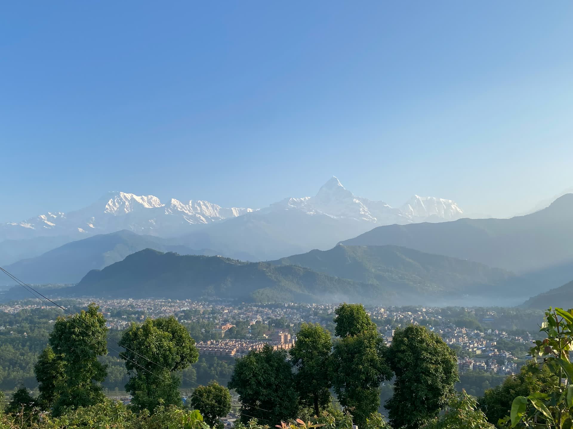
Why 1,600 meters is enough for spectacular views: the elevation gain of roughly 800 meters above the Pokhara Valley floor is enough to lift visitors above the morning ground fog and haze that frequently blankets the valley at lower elevations, particularly in the hours around dawn. This is a straightforward atmospheric effect — cooler, denser air and moisture tend to settle in the valley bottom overnight, while Sarangkot’s ridge sits clear of that layer, giving unobstructed sightlines to peaks that are themselves 5,000 to 6,500+ meters higher still.
Why 1,600 meters carries no altitude sickness risk: Acute Mountain Sickness (AMS) typically doesn’t become a genuine concern until around 2,500 meters and above, and even then, risk scales with how quickly you ascend to that height. Sarangkot, at roughly 1,600 meters, sits well below that threshold — for context, it’s actually lower in elevation than Kathmandu’s own baseline altitude by only a small margin, and travelers routinely spend days in Kathmandu without any altitude-related symptoms. The only physical sensation most visitors notice at Sarangkot is the cold at pre-dawn hours, not anything related to reduced oxygen.
This combination — real elevation benefit, zero altitude risk — is a significant part of why Sarangkot works so well as a mass-tourism sunrise destination in a way that, say, Poon Hill (at over 3,200 meters, requiring genuine acclimatization awareness) simply doesn’t.
Temperature at Sarangkot Elevation, by Season
Elevation directly shapes temperature, and Sarangkot’s roughly 800-meter gain over Pokhara produces a noticeable, if moderate, cooling effect — most pronounced in the pre-dawn hours when most visitors are actually there.
| Season | Typical Pokhara (Lakeside) Morning Temp | Typical Sarangkot Pre-Dawn Temp | Difference |
|---|---|---|---|
| Winter (Dec–Feb) | 8–12°C | 2–6°C | Noticeably colder, warm layers essential |
| Spring (Mar–May) | 14–18°C | 9–13°C | Cool but comfortable with a light jacket |
| Summer/Monsoon (Jun–Aug) | 20–24°C | 16–19°C | Mild, though views are frequently obscured by cloud regardless of temperature |
| Autumn (Sep–Nov) | 14–19°C | 9–14°C | Cool, crisp, generally the most comfortable combination of temperature and visibility |
The elevation-driven temperature drop is a genuinely common surprise for first-time visitors — Pokhara itself often feels comfortably warm even on a winter morning, but the roughly 5–6°C additional drop at Sarangkot’s elevation, combined with pre-dawn timing and open-air exposure on the ridge, can catch underdressed visitors off guard, particularly between December and February.
Elevation Gain by Route: What Each Method of Reaching Sarangkot Actually Involves
| Method | Elevation Gain Experienced | Notes |
|---|---|---|
| Private taxi/car | ~770–850 m, covered passively via the winding road | No physical effort required |
| Annapurna Cable Car | ~770–850 m, covered in about 10 minutes over a 2.2–2.4 km gondola line | The most efficient way to experience the elevation gain without any walking |
| Hiking from Lakeside | ~850 m gained actively over roughly 8–9 km of trail | Genuine, moderate physical exertion; 3–4 hours typical |
| Hiking from Miruwa (Pokhara-Baglung Highway) | A shorter, steeper alternative trailhead; commonly cited as a 90-minute to 2-hour climb | A less-used but valid alternative starting point referenced in several general references |
Both hiking routes ultimately cover a similar total elevation gain, but differ meaningfully in gradient and distance — the Miruwa approach via the Pokhara-Baglung Highway is generally described as a steeper, more direct climb over a shorter distance, while the Lakeside route is longer but gentler.
Does Sarangkot Elevation Affect Paragliding?
Yes, directly — Sarangkot’s roughly 800-meter elevation advantage over the Pokhara Valley floor is precisely what makes it such a renowned paragliding launch site. Tandem paragliding flights typically launch from near the Sarangkot ridge and glide down to landing zones near Phewa Lake, using that elevation difference to sustain a flight of typically 20 to 30 minutes, depending on thermal conditions and pilot routing.
Without this specific elevation gap between the launch point and the valley floor, the flight simply wouldn’t have the vertical distance needed to work as a sustained paragliding experience rather than a brief descent.
Sarangkot Elevation and Visibility: Why Season Matters More Than the Number Itself
A common misconception is that Sarangkot’s fixed elevation should produce a consistently reliable view year-round. In practice, the elevation is constant, but atmospheric conditions at that elevation vary enormously by season, which is why visibility quality — not the height itself — is the real variable worth planning around.
| Season | Effect at Sarangkot’s Elevation |
|---|---|
| Autumn (Sep–Nov) | Clean, dry post-monsoon air; the elevation reliably clears the valley’s morning fog layer |
| Spring (Mar–May) | Similarly good, occasionally affected by pre-monsoon haze in late May |
| Winter (Dec–Feb) | Often very clear, cold, dry air; elevation advantage works reliably, though occasional winter fog can still form |
| Monsoon (Jun–Aug) | Cloud cover frequently sits at or above Sarangkot’s elevation itself, meaning the height advantage doesn’t help — you can be above the valley fog and still be inside the clouds |
This last point is the one most visitors don’t anticipate: during monsoon season, the cloud base can actually sit at or below Sarangkot’s own elevation, meaning the hill’s height advantage over the valley floor doesn’t translate into clear views the way it reliably does in autumn and winter — you can be standing above the fog and still be inside cloud cover blocking the mountains entirely.
Geographic and Historical Context of Sarangkot Elevation
Sarangkot’s ridge historically held a fort belonging to the small Kingdom of Kaski, one of several regional principalities that existed in this part of Nepal before the country’s unification in the 18th century. Its elevated, defensible position — the same height advantage that today makes it a scenic viewpoint — was originally a strategic military asset, giving clear sightlines over the surrounding valley approaches. The fort ruins remain visible near the summit today, a detail many sunrise visitors walk past without realizing its historical significance.
Common Sarangkot Elevation-Related Questions Travelers Actually Ask
Beyond the core “how high is it” question, a few elevation-adjacent practical questions come up often enough to address directly:
- “Will I feel short of breath at Sarangkot?” No — at roughly 1,600 meters, there’s no meaningful reduction in available oxygen that would cause breathlessness during normal activity. Any breathlessness during the hiking route is a function of the physical exertion of climbing roughly 800 meters over a few hours, not the elevation’s effect on oxygen levels.
- “Do I need to acclimatize before visiting Sarangkot?” No. Acclimatization becomes a genuine consideration above roughly 2,500 meters, and Sarangkot sits well below that. You can visit Sarangkot immediately upon arrival in Pokhara without any adjustment period.
- “Is Sarangkot higher or lower than where I’ll sleep in Pokhara?” Higher, by roughly 770–850 meters depending on exactly where in Pokhara you’re staying — this is the elevation gain your taxi, cable car, or hike actually covers.
- “Does the elevation affect how cold it feels?” Yes, meaningfully — expect a real, noticeable temperature drop compared to Pokhara itself, particularly in the pre-dawn hours, as detailed in the temperature table above.
Sarangkot Elevation in the Context of a Broader Nepal Trip
If Sarangkot is one stop in a wider Nepal itinerary, its modest elevation is worth understanding relative to what else you might be doing on the same trip.
| If You’re Also Visiting… | Elevation | How It Compares to Sarangkot |
|---|---|---|
| Kathmandu | ~1,400 m | Slightly lower than Sarangkot |
| Chitwan National Park | ~150 m | Dramatically lower — a lowland, subtropical environment |
| Nagarkot | ~2,100+ m | Noticeably higher, a comparable but more elevated equivalent viewpoint |
| Poon Hill (Annapurna region) | ~3,210 m | Over 1,600 m higher, reached only via a multi-day trek |
| Everest Base Camp | ~5,364 m | Nearly 3,800 m higher — an entirely different undertaking requiring serious acclimatization |
| Muktinath | ~3,700–3,800 m | Over twice Sarangkot’s elevation |
Seeing Sarangkot in this context helps calibrate expectations: it’s a genuinely rewarding, low-effort mountain viewpoint, but it sits at the low end of Nepal’s tourism-elevation spectrum — a half-day excursion requiring essentially no physical preparation, rather than a milestone toward higher-altitude trekking goals elsewhere in the country.
What We’ve Learned About Sarangkot Elevation From Running Trips There

The most common elevation-related misunderstanding we encounter at Trek Trove Nepal isn’t about the number itself — it’s travelers assuming that because Sarangkot delivers views comparable in drama to much higher Himalayan viewpoints, it must require similar preparation. It doesn’t. The entire appeal of Sarangkot is that it delivers an outsized visual reward for a genuinely modest 800-meter elevation gain, covered in minutes by cable car or taxi, or a few unhurried hours on foot — no altitude planning, no acclimatization day, no special gear beyond a warm layer for the pre-dawn chill.
Where the elevation does matter practically is in packing and timing: because the temperature drop at Sarangkot’s height is real, if modest, we consistently advise travelers — especially in the December to February window — to bring a proper jacket even if Pokhara itself feels comfortably mild the evening before.
Frequently Asked Questions about Sarangkot Elevation
1. What is the exact Sarangkot Elevation?
Most reliable sources place it at approximately 1,592 to 1,600 meters (5,223 to 5,249 feet) above sea level, with Wikipedia and most administrative sources using the rounded figure of 1,600 meters.
2. Why do different websites give different elevation figures for Sarangkot?
The variation is small (generally under 100 meters) and likely reflects different survey precision or slightly different reference points on the hill — such as the main viewing platform versus the higher fort ruins nearby — rather than any genuine disagreement about the location.
3. How much elevation do I gain going from Pokhara to Sarangkot?
Approximately 770 to 858 meters, depending on your exact starting point in Pokhara (Lakeside, the city center, or Phewa Lake itself).
4. Is Sarangkot’s elevation high enough to cause altitude sickness?
No. Altitude sickness typically becomes a concern above roughly 2,500 meters, and Sarangkot sits well below that threshold. No acclimatization or special precaution is needed.
5. How does Sarangkot’s elevation compare to Kathmandu’s?
Sarangkot, at roughly 1,600 meters, sits only about 200 meters higher than Kathmandu itself, which sits at approximately 1,400 meters.
6. Is Sarangkot higher than Nagarkot, the similar viewpoint near Kathmandu?
No — Nagarkot sits considerably higher, at roughly 2,100 meters or more, compared to Sarangkot’s approximately 1,600 meters.
7. Does Sarangkot’s elevation guarantee clear mountain views?
No — while the elevation reliably lifts visitors above the Pokhara Valley’s morning fog in most seasons, cloud cover during monsoon season can sit at or below Sarangkot’s own elevation, meaning height alone doesn’t guarantee visibility.
8. How cold does it get at Sarangkot’s elevation during sunrise?
It varies by season, but expect temperatures roughly 4 to 6°C cooler than Pokhara itself at the same hour, with winter pre-dawn temperatures commonly dropping to the 2–6°C range.
9. What is Sarangkot’s elevation in feet?
Approximately 5,223 to 5,249 feet, depending on which of the commonly cited meter figures (1,592 m or 1,600 m) you’re converting from.
10. Does the elevation gain differ if I hike versus drive?
The total elevation gained is essentially the same regardless of method — roughly 770 to 858 meters — the difference is simply whether you cover that gain actively on foot over several hours, or passively by vehicle or cable car in well under an hour.
11. Is Sarangkot higher than Dhulikhel, the similar viewpoint near Kathmandu?
They’re very close — Dhulikhel sits at approximately 1,550 meters, essentially comparable to Sarangkot’s 1,592–1,600 meters, making them broadly similar experiences in elevation terms, though in different regions of Nepal.
12. Why does Sarangkot feel more dramatic than its elevation number suggests?
Because the drama comes from proximity to much higher peaks, not Sarangkot’s own height — you’re viewing mountains 5,000 to 6,500+ meters higher than your own vantage point from a relatively modest, easily reached elevation, which is a large part of what makes the panorama so striking for comparatively little effort.
13. Do I need special gear because of the elevation?
No specialized altitude gear is needed — a warm layer for the pre-dawn cold, comfortable shoes if hiking, and standard travel essentials are sufficient. This isn’t a high-altitude environment requiring specialized equipment.
14. How does Sarangkot’s elevation compare to Poon Hill, another famous Pokhara-area viewpoint?
Poon Hill sits considerably higher, at approximately 3,210 meters — over 1,600 meters higher than Sarangkot — and requires a multi-day trek to reach, compared to Sarangkot’s half-day, no-preparation-needed accessibility.
Final Word on Sarangkot Elevation
Sarangkot’s elevation — somewhere in the narrow 1,592 to 1,600 meter range, depending on which reliable source you check — is really the whole story of why the place works as well as it does: high enough to clear the valley haze and deliver a genuinely dramatic mountain panorama, low enough to require nothing more than a warm layer and a reasonably early alarm.
Whatever exact figure you see quoted, treat the 100-meter spread across sources as noise rather than signal, and focus your actual planning on the variable that matters far more than the number on a map — the season and the morning’s weather.
